
Servion topographic map
Interactive map
Click on the map to display elevation.
About this map
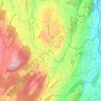
Name: Servion topographic map, elevation, terrain.
Location: Servion, District de Lavaux-Oron, Vaud, Suisse (46.56151 6.74276 46.58572 6.79922)
Average elevation: 728 m
Minimum elevation: 589 m
Maximum elevation: 864 m
Other topographic maps
Click on a map to view its topography, its elevation and its terrain.
Bourg-en-Lavaux
Suisse > Vaud > District de Lavaux-Oron
Bourg-en-Lavaux, District de Lavaux-Oron, Vaud, Suisse
Average elevation: 642 m
Oron
Suisse > Vaud > District de Lavaux-Oron
Oron, District de Lavaux-Oron, Vaud, Suisse
Average elevation: 710 m
Belmont
Suisse > Vaud > District de Lavaux-Oron
Belmont, District de Lavaux-Oron, Vaud, 1092, Suisse
Average elevation: 656 m