
Cazaux-Layrisse topographic map
Interactive map
Click on the map to display elevation.
About this map
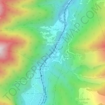
Name: Cazaux-Layrisse topographic map, elevation, terrain.
Average elevation: 877 m
Minimum elevation: 558 m
Maximum elevation: 1,474 m
La superficie de la commune est de 276 hectares ; son altitude varie de 589 à 1 776 mètres.
Other topographic maps
Click on a map to view its topography, its elevation and its terrain.
Pont de Cazaux
France > Occitanie > Haute-Garonne > Cazaux-Layrisse
Pont de Cazaux, Cazaux-Layrisse, Saint-Gaudens, Haute-Garonne, Occitanie, France métropolitaine, 31440, France
Average elevation: 964 m