Geolocate

Mt. Ontake topographic map

Click on the map to display elevation.

About this map

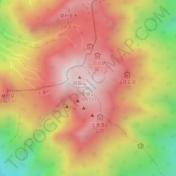
Name: Mt. Ontake topographic map, elevation, terrain.

Location: Mt. Ontake, Otaki, Kiso District, Nagano Prefecture, Japan (35.89294 137.48036 35.89304 137.48046)

Average elevation: 2,674 m

Minimum elevation: 2,109 m

Maximum elevation: 3,048 m

Gear up for your next adventure:

🚲Cycling GPS Computers - Track elevation and topographic routes on two wheels
🧦Hiking Socks - Breathable socks designed to prevent blisters on long walks
👕Merino Base Layers - Natural temperature regulation for cold weather hiking and camping
🥾Trekking Poles - Poles to improve stability on uneven terrain
🎒Hiking Daypacks (20L) - Compact backpacks for day trips and technical mountain ascents

As an Amazon Associate, this site earns from qualifying purchases at no extra cost to you.