
Make a donation
Gear up for your next adventure:
As an Amazon Associate, this site earns from qualifying purchases at no extra cost to you.
Andorra la Vella topographic map
Click on the map to display elevation.
Make a donation
Gear up for your next adventure:
As an Amazon Associate, this site earns from qualifying purchases at no extra cost to you.
Andorra la Vella
The principal industry is tourism, although the country also earns foreign income from being a tax haven. Furniture and brandies are local products. Being at an elevation of 1,023 m (3,356 ft), it is the highest capital city in Europe and a popular ski resort.
Make a donation
Gear up for your next adventure:
As an Amazon Associate, this site earns from qualifying purchases at no extra cost to you.
About this map
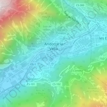
Name: Andorra la Vella topographic map, elevation, terrain.
Location: Andorra la Vella, AD500, Andorra (42.49665 1.50531 42.51348 1.53425)
Average elevation: 1,270 m
Minimum elevation: 978 m
Maximum elevation: 2,115 m
Make a donation
Gear up for your next adventure:
As an Amazon Associate, this site earns from qualifying purchases at no extra cost to you.
Other topographic maps
Click on a map to view its topography, its elevation and its terrain.