Geolocate

Ditcheat topographic map

Click on the map to display elevation.

About this map

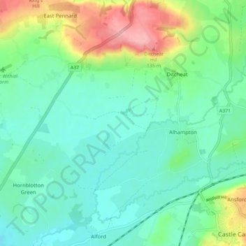
Name: Ditcheat topographic map, elevation, terrain.

Location: Ditcheat, Somerset, England, United Kingdom (51.09127 -2.58530 51.13550 -2.49858)

Average elevation: 56 m

Minimum elevation: 23 m

Maximum elevation: 144 m

Somerset trails, hiking, mountain biking, running and outdoor activities

Gear up for your next adventure:

🚲Bikepacking Frame Bags - Storage for tools and navigation gear on long off-road rides
🥼Base Layers - Thermal base layers for temperature regulation
🧼Camping Hygiene Kits - Compact hygiene essentials for outdoor stays
🩹Hiking First Aid Kits - Compact medical kits tailored for trail injuries and emergencies
🔋Lithium AA Batteries - Long-lasting power that performs well in cold mountain weather

As an Amazon Associate, this site earns from qualifying purchases at no extra cost to you.