
Make a donation
Gear up for your next adventure:
As an Amazon Associate, this site earns from qualifying purchases at no extra cost to you.
Ovejas topographic map
Click on the map to display elevation.
Make a donation
Gear up for your next adventure:
As an Amazon Associate, this site earns from qualifying purchases at no extra cost to you.
Ovejas
奧韋哈斯是哥倫比亞的城鎮,位於該國北部,由蘇克雷省負責管轄,距離首府辛塞萊霍41公里,面積447平方公里,海拔高度254米,2005年人口20,551。
Make a donation
Gear up for your next adventure:
As an Amazon Associate, this site earns from qualifying purchases at no extra cost to you.
About this map
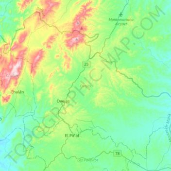
Name: Ovejas topographic map, elevation, terrain.
Location: Ovejas, Montes de María, Sucre, RAP Caribe, 哥伦比亚 / 哥倫比亞 (9.42154 -75.32549 9.68614 -75.01496)
Average elevation: 241 m
Minimum elevation: 90 m
Maximum elevation: 686 m
Make a donation
Gear up for your next adventure:
As an Amazon Associate, this site earns from qualifying purchases at no extra cost to you.
Other topographic maps
Click on a map to view its topography, its elevation and its terrain.
辛塞萊霍
哥伦比亚 / 哥倫比亞 > Sucre > Sincelejo
辛塞萊霍(西班牙語:Sincelejo,西班牙语发音:[sinseˈlexo])是哥倫比亞的城市,位於該國北部,也是苏克雷省的省会,距離巴蘭基亞220公里,始建於1776年11月21日,面積为278.4平方公里,海拔高度213米,2016年人口为279,031。
Average elevation: 121 m