Geolocate

Dourgouti Region topographic map

Interactive map

Click on the map to display elevation.

About this map

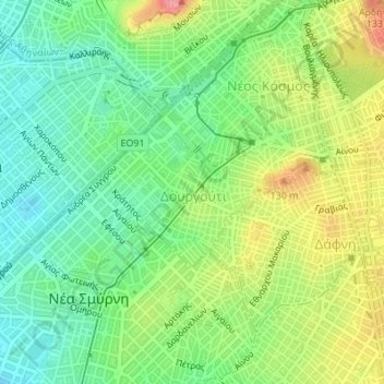
Name: Dourgouti Region topographic map, elevation, terrain.

Location: Dourgouti Region, Dourgouti, 2nd District of Athens, Athens, Municipality of Athens, Regional Unit of Central Athens, Attica, Greece (37.94884 23.71487 37.95948 23.73590)

Average elevation: 73 m

Minimum elevation: 26 m

Maximum elevation: 148 m

Other topographic maps

Click on a map to view its topography, its elevation and its terrain.

Lycabettus

Greece > Attica > Regional Unit of Central Athens > Athens

Lycabettus, Δώρας Δ' Ίστρια, Kolonaki, Συνοικία Κολωνακίου, 1st District of Athens, Athens, Municipality of Athens, Regional Unit of Central Athens, Attica, 106 76, Greece

Average elevation: 125 m

Philopappos Hill

Greece > Attica > Regional Unit of Central Athens > Athens

Philopappos Hill, Athens, Municipality of Athens, Regional Unit of Central Athens, Attica, 117 41, Greece

Average elevation: 73 m

Άλσος Βεΐκου

Greece > Attica > Regional Unit of Central Athens > Athens

Άλσος Βεΐκου, Galatsi, Athens, Municipality of Galatsi, Regional Unit of Central Athens, Attica, Greece

Average elevation: 171 m

Ιλισσός

Greece > Attica > Regional Unit of Central Athens > Athens

Ιλισσός, 7th District of Athens, Athens, Municipality of Athens, Regional Unit of Central Athens, Attica, 11527, Greece

Average elevation: 140 m