Geolocate

Curra topographic map

Click on the map to display elevation.

About this map

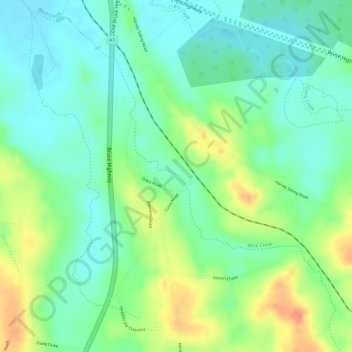
Name: Curra topographic map, elevation, terrain.

Location: Curra, Gympie, Queensland, Australia (-26.08084 152.57943 -26.06084 152.59943)

Average elevation: 67 m

Minimum elevation: 46 m

Maximum elevation: 98 m

Other topographic maps

Click on a map to view its topography, its elevation and its terrain.

Lake Borumba

Australia > Queensland > Gympie

Average elevation: 257 m

Queens Park

Australia > Queensland > Gympie

Average elevation: 63 m

Gear up for your next adventure:

🧥Breathable Waterproof Jackets - Essential rain protection for the unpredictable British climate
🎒Hiking Daypacks - Compact backpacks ideal for short hikes and excursions
👖Convertible Hiking Trousers - Versatile zip-off pants for changing mountain weather conditions
🐕Hiking Dog Harnesses - Rugged harnesses for taking your companion on mountain trails
🛰️Handheld GPS Devices - Reliable GPS units for hiking and outdoor navigation

As an Amazon Associate, this site earns from qualifying purchases at no extra cost to you.