
Iztaccíhuatl topographic map
Interactive map
Click on the map to display elevation.
About this map
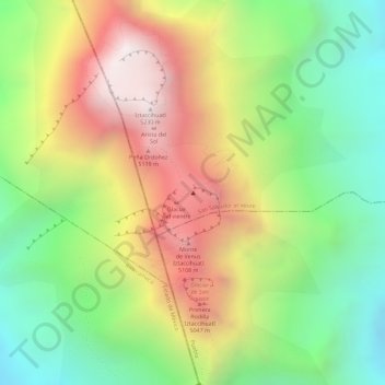
Name: Iztaccíhuatl topographic map, elevation, terrain.
Location: Iztaccíhuatl, San Salvador el Verde, Puebla, Mexico (19.17015 -98.63764 19.17025 -98.63754)
Average elevation: 4,732 m
Minimum elevation: 4,293 m
Maximum elevation: 5,221 m
The name "Iztaccíhuatl" is Nahuatl for "White woman", reflecting the four individual snow-capped peaks which depict the head, chest, knees and feet of a sleeping female when seen from east or west. Iztaccíhuatl is to the north of its twin Popocatépetl, to which it is connected by the high altitude Paso de Cortés. Depending on atmospheric conditions Iztaccíhuatl is visible much of the year from Mexico City some 70 km (43 mi) to the northwest. The first recorded ascent was made in 1889, though archaeological evidence suggests the Aztecs and previous cultures climbed it previously. It is the lowest peak containing permanent snow and glaciers in Mexico.
Other topographic maps
Click on a map to view its topography, its elevation and its terrain.
Cerro Tehuicocone
Mexico > Puebla > San Salvador el Verde
Cerro Tehuicocone, San Salvador el Verde, Puebla, Mexico
Average elevation: 4,260 m