
Aloag topographic map
Interactive map
Click on the map to display elevation.
About this map
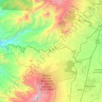
Name: Aloag topographic map, elevation, terrain.
Location: Aloag, Machachi, Pichincha, Ecuador (-0.53897 -78.73395 -0.35977 -78.55222)
Average elevation: 3,109 m
Minimum elevation: 1,912 m
Maximum elevation: 4,771 m
Other topographic maps
Click on a map to view its topography, its elevation and its terrain.
Santuario de Baños
Ecuador > Pichincha > Machachi > Manuel Cornejo Astorga (Tandapi)
Santuario de Baños, Manuel Cornejo Astorga (Tandapi), Machachi, Pichincha, Ecuador
Average elevation: 1,632 m
Volcán Cotopaxi
Ecuador > Pichincha > Machachi > Machachi
Volcán Cotopaxi, Machachi, Pichincha, Ecuador
Average elevation: 5,021 m