
Make a donation
Gear up for your next adventure:
As an Amazon Associate, this site earns from qualifying purchases at no extra cost to you.
Scales Mound topographic map
Click on the map to display elevation.
Make a donation
Gear up for your next adventure:
As an Amazon Associate, this site earns from qualifying purchases at no extra cost to you.
Scales Mound
Scales Mound is located in a region of the U.S. Midwest known as the Driftless Area, so called because it escaped glaciation during the last ice age. It covers parts of Illinois, Wisconsin, Minnesota and Iowa. The Illinois section is mostly limited to Jo Daviess County and small parts of Whiteside and Carroll County in northwest Illinois. The topography of the area is characterized by hilly terrain and wooded ridges. Common features found in the Scales Mound area include canyons, bluffs, ravines and palisades. Near Charles Mound, the highest point in Illinois at 1235 feet, Scales Mound is said to be "At the Top of Illinois".
Make a donation
Gear up for your next adventure:
As an Amazon Associate, this site earns from qualifying purchases at no extra cost to you.
About this map
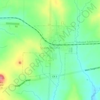
Name: Scales Mound topographic map, elevation, terrain.
Average elevation: 294 m
Minimum elevation: 258 m
Maximum elevation: 361 m
Make a donation
Gear up for your next adventure:
As an Amazon Associate, this site earns from qualifying purchases at no extra cost to you.
Other topographic maps
Click on a map to view its topography, its elevation and its terrain.