Geolocate

Formby topographic map

Click on the map to display elevation.

About this map

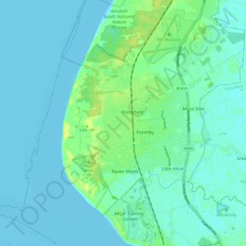
Name: Formby topographic map, elevation, terrain.

Location: Formby, Sefton, Liverpool City Region, England, United Kingdom (53.52788 -3.13194 53.58944 -3.02071)

Average elevation: 5 m

Minimum elevation: 0 m

Maximum elevation: 21 m

England trails, hiking, mountain biking, running and outdoor activities

Other topographic maps

Click on a map to view its topography, its elevation and its terrain.

Formby

United Kingdom > England > Sefton

Average elevation: 5 m

Litherland

United Kingdom > England > Sefton

Average elevation: 17 m

Southport

United Kingdom > England > Sefton

Average elevation: 4 m

Crosby

United Kingdom > England > Sefton

Average elevation: 9 m

Melling Mount

United Kingdom > England > Sefton

Average elevation: 30 m

Bootle

United Kingdom > England > Sefton

Average elevation: 22 m

Southport

United Kingdom > England > Sefton

Average elevation: 4 m

Southport

United Kingdom > England > Sefton

Average elevation: 4 m

Melling Mount

United Kingdom > England > Sefton

Average elevation: 30 m

Southport

United Kingdom > England > Sefton

Average elevation: 4 m

Southport

United Kingdom > England > Sefton

Average elevation: 4 m

Southport

United Kingdom > England > Sefton

Average elevation: 4 m

Southport

United Kingdom > England > Sefton

Average elevation: 4 m

Southport

United Kingdom > England > Sefton

Average elevation: 4 m

Gear up for your next adventure:

📱Rugged Phone Cases - Heavy-duty protection for smartphones used as secondary GPS tools
Altimeter Watches - Watches measuring altitude for mountain activities
🔋Lithium AA Batteries - Long-lasting power that performs well in cold mountain weather
🦟Anti-Midge & Tick Repellent - Vital for hiking in the Scottish Highlands during summer
🔦Outdoor Torches - Reliable torches for night navigation

As an Amazon Associate, this site earns from qualifying purchases at no extra cost to you.