Geolocate

Centerville topographic map

Click on the map to display elevation.

About this map

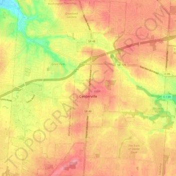
Name: Centerville topographic map, elevation, terrain.

Location: Centerville, Montgomery County, Ohio, United States (39.59062 -84.20869 39.67385 -84.09909)

Average elevation: 287 m

Minimum elevation: 226 m

Maximum elevation: 323 m

Other topographic maps

Click on a map to view its topography, its elevation and its terrain.

Cornell Heights

United States > Ohio > Montgomery County > Dayton

Average elevation: 256 m

Hearthstone

United States > Ohio > Montgomery County > Dayton

Average elevation: 273 m

Oakdale

United States > Ohio > Montgomery County > Kettering

Average elevation: 297 m

Fort McKinley

United States > Ohio > Montgomery County > Dayton

Average elevation: 273 m

Bridgeport

United States > Ohio > Montgomery County > Miamisburg

Average elevation: 243 m

Patterson

United States > Ohio > Montgomery County > Dayton

Average elevation: 233 m

Oakland

United States > Ohio > Montgomery County > Dayton

Average elevation: 269 m

Dayton

United States > Ohio > Montgomery County > Dayton

Average elevation: 270 m

North Riverdale

United States > Ohio > Montgomery County > Dayton

Average elevation: 254 m

Shakertown

United States > Ohio > Montgomery County > Kettering

Average elevation: 282 m

Hearthstone

United States > Ohio > Montgomery County > Dayton

Average elevation: 273 m

Gear up for your next adventure:

🧥Waterproof Hiking Jackets - Rain protection for walking in all weather conditions
🦶Anti-Blister Balms - Protect your feet before long topographic expeditions
🛌Sleeping Bags - Warm and packable sleeping bags for outdoor nights
📚UK Hiking Guidebooks - Detailed route descriptions for the Lake District, Peaks, and Highlands
🔭Compact Hiking Binoculars - Lightweight optics for scouting terrain and spotting wildlife

As an Amazon Associate, this site earns from qualifying purchases at no extra cost to you.