
Cumberland Island National Seashore topographic map
Interactive map
Click on the map to display elevation.
About this map
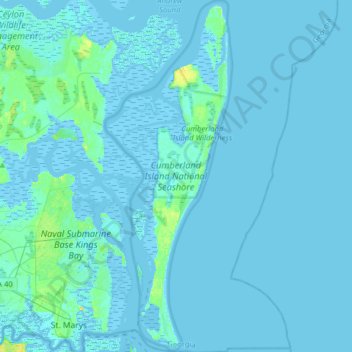
Name: Cumberland Island National Seashore topographic map, elevation, terrain.
Average elevation: 1 m
Minimum elevation: -4 m
Maximum elevation: 21 m
Other topographic maps
Click on a map to view its topography, its elevation and its terrain.
St. Marys
United States > Georgia > Camden County > St. Marys
St. Marys, Camden County, Georgia, United States
Average elevation: 3 m