
Bernried topographic map
Interactive map
Click on the map to display elevation.
About this map
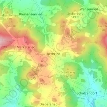
Name: Bernried topographic map, elevation, terrain.
Location: Bernried, Rötz, Landkreis Cham, Bayern, 92444, Deutschland (49.29083 12.52622 49.33083 12.56622)
Average elevation: 521 m
Minimum elevation: 428 m
Maximum elevation: 643 m
Other topographic maps
Click on a map to view its topography, its elevation and its terrain.
Grassersdorf
Deutschland > Bayern > Landkreis Cham > Rötz
Grassersdorf, Rötz, Landkreis Cham, Bayern, 92444, Deutschland
Average elevation: 482 m
Stanglhof
Deutschland > Bayern > Landkreis Cham > Rötz > Wenzenried
Stanglhof, Wenzenried, Rötz, Landkreis Cham, Bayern, 93488, Deutschland
Average elevation: 512 m
Gruberberg
Deutschland > Bayern > Landkreis Cham > Rötz
Gruberberg, Rötz, Landkreis Cham, Bayern, 92444, Deutschland
Average elevation: 504 m