
Kocatepe Mahallesi topographic map
Interactive map
Click on the map to display elevation.
About this map
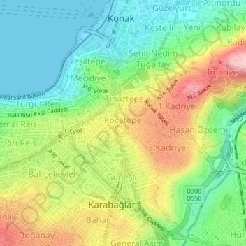
Name: Kocatepe Mahallesi topographic map, elevation, terrain.
Location: Kocatepe Mahallesi, Izmir, Konak, İzmir, Ege Bölgesi, Turquie (38.40514 27.12828 38.40879 27.13145)
Average elevation: 74 m
Minimum elevation: 0 m
Maximum elevation: 186 m
Other topographic maps
Click on a map to view its topography, its elevation and its terrain.
Millet Mahallesi
Millet Mahallesi, Izmir, Konak, İzmir, Région Égéenne, Turquie
Average elevation: 132 m