
Patheingyi Township topographic map
Interactive map
Click on the map to display elevation.
About this map
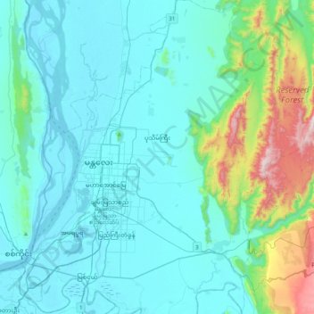
Name: Patheingyi Township topographic map, elevation, terrain.
Average elevation: 202 m
Minimum elevation: 60 m
Maximum elevation: 1,048 m
Other topographic maps
Click on a map to view its topography, its elevation and its terrain.
Ayeyarwaddy International School
Myanmar > Mandalay > Mandalay District > Mandalay > Chanayethazan Township
Ayeyarwaddy International School, Mandalay, Chanayethazan Township, Mandalay District, Mandalay, 0502-2050, Myanmar
Average elevation: 78 m