
Hingene topographic map
Interactive map
Click on the map to display elevation.
About this map
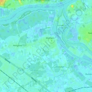
Name: Hingene topographic map, elevation, terrain.
Location: Hingene, Bornem, Malines, Anvers, Flandre, 2889, Belgique (51.08039 4.24911 51.12559 4.32683)
Average elevation: 3 m
Minimum elevation: -3 m
Maximum elevation: 22 m
Other topographic maps
Click on a map to view its topography, its elevation and its terrain.
Château Marnix de Sainte Aldegonde
Château Marnix de Sainte Aldegonde, 35, Kasteelstraat, Bornem, Malines, Anvers, Flandre, 2880, Belgique
Average elevation: 2 m