Geolocate

Ruaka topographic map

Click on the map to display elevation.

About this map
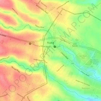
Name: Ruaka topographic map, elevation, terrain.

Location: Ruaka, Kiambaa, Kiambu, Kenya (-1.21379 36.76671 -1.20169 36.79327)

Average elevation: 1,753 m

Minimum elevation: 1,698 m

Maximum elevation: 1,790 m

Other topographic maps

Click on a map to view its topography, its elevation and its terrain.

Muchatha ward

Kenya > Kiambu > Kiambaa

Average elevation: 1,793 m

karuri

Kenya > Kiambu > Kiambaa > Karuri ward

Average elevation: 1,865 m

Ndenderu ward

Kenya > Kiambu > Kiambaa

Average elevation: 1,854 m

Cianda ward

Kenya > Kiambu > Kiambaa

Average elevation: 1,887 m

Gear up for your next adventure:

🧵Survival Paracord - Multi-purpose cordage for emergency repairs and shelters
📦Dry Bags - Waterproof bags to protect gear from rain
🧭Professional Hiking Compasses - High-precision liquid-filled compasses for map reading and orientation
🛌Sleeping Mats - Insulated mats for comfortable outdoor sleeping
👕Merino Base Layers - Natural temperature regulation for cold weather hiking and camping

As an Amazon Associate, this site earns from qualifying purchases at no extra cost to you.