
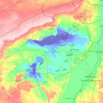
Faiyum topographic map
Interactive map
Click on the map to display elevation.
About this map
Name: Faiyum topographic map, elevation, terrain.
Location: Faiyum, Egypt (28.96146 29.85055 29.71627 31.12299)
Average elevation: 101 m
Minimum elevation: -49 m
Maximum elevation: 348 m
Other topographic maps
Click on a map to view its topography, its elevation and its terrain.
New Cairo City
Located in what was formerly Helwan Governorate, and located to the east of Maadi and Heliopolis, New Cairo ranges in elevation between 250 and 307 metres (820 and 1,007 ft) above sea level.
Average elevation: 227 m
الحي الخامس منطقة 2
Egypt > Cairo > Cairo > Districts of El Tagamoa El Khames
Average elevation: 277 m
Gabal Elba
In the higher-elevation mist zone, species of acacia, Moringa and Gabal Elba dragon tree (Dracaena ombet) form the woodland tree canopy, with ferns, mosses and succulents in the understory. The mountain intercepts moisture-bearing winds from the northeast, and the northern and northeastern slopes are more…
Average elevation: 1,004 m
New Cairo City
New Cairo is built in the Eastern Desert to the east of the Cairo Ring Road and the modern 1950s extension of Nasr City, on a plateau that ranges in elevation between 250 and 307 metres (820 and 1,007 ft) above sea level.
Average elevation: 227 m
New Cairo City
New Cairo is built in the Eastern Desert to the east of the Cairo Ring Road and the modern 1950s extension of Nasr City, on a plateau that ranges in elevation between 250 and 307 metres (820 and 1,007 ft) above sea level.
Average elevation: 227 m