
Make a donation
Gear up for your next adventure:
As an Amazon Associate, this site earns from qualifying purchases at no extra cost to you.
Gabal Elba topographic map
Click on the map to display elevation.
Make a donation
Gear up for your next adventure:
As an Amazon Associate, this site earns from qualifying purchases at no extra cost to you.
Gabal Elba
In the higher-elevation mist zone, species of acacia, Moringa and Gabal Elba dragon tree (Dracaena ombet) form the woodland tree canopy, with ferns, mosses and succulents in the understory. The mountain intercepts moisture-bearing winds from the northeast, and the northern and northeastern slopes are more humid than the western and southern slopes. Savannas of acacia and Delonix grow in the foothills and along watercourses. The mountain is home to the largest remaining population of Dracaena ombet in Egypt and Sudan.
Make a donation
Gear up for your next adventure:
As an Amazon Associate, this site earns from qualifying purchases at no extra cost to you.
About this map
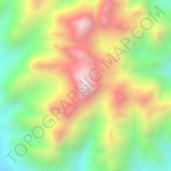
Name: Gabal Elba topographic map, elevation, terrain.
Location: Gabal Elba, Red Sea, Egypt (22.16785 36.36483 22.16795 36.36493)
Average elevation: 1,004 m
Minimum elevation: 599 m
Maximum elevation: 1,412 m
Make a donation
Gear up for your next adventure:
As an Amazon Associate, this site earns from qualifying purchases at no extra cost to you.
Other topographic maps
Click on a map to view its topography, its elevation and its terrain.
Make a donation
Gear up for your next adventure:
As an Amazon Associate, this site earns from qualifying purchases at no extra cost to you.
Make a donation
Gear up for your next adventure:
As an Amazon Associate, this site earns from qualifying purchases at no extra cost to you.
Make a donation
Gear up for your next adventure:
As an Amazon Associate, this site earns from qualifying purchases at no extra cost to you.
Make a donation
Gear up for your next adventure:
As an Amazon Associate, this site earns from qualifying purchases at no extra cost to you.