
Sistan-et-Baloutchistan topographic map
Interactive map
Click on the map to display elevation.
About this map
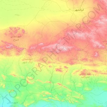
Name: Sistan-et-Baloutchistan topographic map, elevation, terrain.
Location: شهرستان نیک شهر, Sistan-et-Baloutchistan, Iran (25.88865 58.84381 27.01395 60.89465)
Average elevation: 604 m
Minimum elevation: 3 m
Maximum elevation: 2,123 m
Other topographic maps
Click on a map to view its topography, its elevation and its terrain.
Khash
Iran > Sistan-et-Baloutchistan > شهرستان خاش
Khash, بخش مرکزی خاش, شهرستان خاش, Sistan-et-Baloutchistan, Iran
Average elevation: 1,423 m
گران
Iran > Sistan-et-Baloutchistan > شهرستان سرباز
گران, بخش سرباز, شهرستان سرباز, Sistan-et-Baloutchistan, Iran
Average elevation: 1,086 m
Nik Shahr
Iran > Sistan-et-Baloutchistan > شهرستان نیک شهر > دهستان هیچان
Nik Shahr, دهستان هیچان, بخش مرکزی, شهرستان نیک شهر, Sistan-et-Baloutchistan, Iran
Average elevation: 501 m
Zahedan
Iran > Sistan-et-Baloutchistan > شهرستان زاهدان
Zahedan, بخش مرکزی, شهرستان زاهدان, Sistan-et-Baloutchistan, Iran
Average elevation: 1,416 m
بخش بزمان
Iran > Sistan-et-Baloutchistan
بخش بزمان, Sistan-et-Baloutchistan, Iran
Average elevation: 983 m
Iran Shahr
Iran > Sistan-et-Baloutchistan > شهرستان ایرانشهر
Iran Shahr, دهستان حومه, بخش مرکزی, شهرستان ایرانشهر, Sistan-et-Baloutchistan, Iran
Average elevation: 628 m
چابهار
Iran > Sistan-et-Baloutchistan > چابهار
Chabahar, چابهار, بخش مرکزی, شهرستان چابهار, Sistan-et-Baloutchistan, 66473, Iran
Average elevation: 13 m
بزمان
Iran > Sistan-et-Baloutchistan > بزمان
بزمان, بخش بزمان, شهرستان ایرانشهر, Sistan-et-Baloutchistan, Iran
Average elevation: 995 m
Chabahar
Iran > Sistan-et-Baloutchistan > شهرستان چابهار
Chabahar, بخش مرکزی, شهرستان چابهار, Sistan-et-Baloutchistan, 99717-66738, Iran
Average elevation: 48 m