
Donauwörth topographic map
Interactive map
Click on the map to display elevation.
About this map
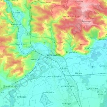
Name: Donauwörth topographic map, elevation, terrain.
Location: Donauwörth, Landkreis Donau-Ries, Bavaria, 86609, Germany (48.67555 10.66884 48.76341 10.86788)
Average elevation: 443 m
Minimum elevation: 394 m
Maximum elevation: 561 m
Other topographic maps
Click on a map to view its topography, its elevation and its terrain.
Rain
Germany > Bavaria > Landkreis Donau-Ries > Rain > Rain
The major cause of rain production is moisture moving along three-dimensional zones of temperature and moisture contrasts known as weather fronts. If enough moisture and upward motion is present, precipitation falls from convective clouds (those with strong upward vertical motion) such as cumulonimbus (thunder…
Average elevation: 405 m