
Eschbach topographic map
Interactive map
Click on the map to display elevation.
About this map
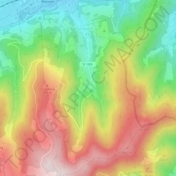
Name: Eschbach topographic map, elevation, terrain.
Average elevation: 630 m
Minimum elevation: 376 m
Maximum elevation: 907 m
Other topographic maps
Click on a map to view its topography, its elevation and its terrain.
Eschbach
Frankreich > Großer Osten > Eschbach
Eschbach, Hagenau-Weißenburg, Unterelsass, Großer Osten, Metropolitanes Frankreich, 67360, Frankreich
Average elevation: 182 m