
Lightning Lake topographic map
Interactive map
Click on the map to display elevation.
About this map
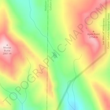
Name: Lightning Lake topographic map, elevation, terrain.
Location: Lightning Lake, Gallatin County, Montana, United States (44.98189 -111.37067 44.98356 -111.36932)
Average elevation: 2,690 m
Minimum elevation: 2,508 m
Maximum elevation: 2,869 m
Other topographic maps
Click on a map to view its topography, its elevation and its terrain.
Bozeman
United States > Montana > Gallatin County
Bozeman, Gallatin County, Montana, United States
Average elevation: 1,495 m
Three Forks
United States > Montana > Gallatin County
Three Forks, Gallatin County, Montana, United States
Average elevation: 1,249 m
Belgrade
United States > Montana > Gallatin County
Belgrade, Gallatin County, Montana, 59714, United States
Average elevation: 1,355 m
Big Sky
United States > Montana > Gallatin County
Big Sky, Gallatin County, Montana, United States
Average elevation: 2,435 m
Bozeman
United States > Montana > Gallatin County > Bozeman
Bozeman, Gallatin County, Montana, 59715, United States
Average elevation: 1,679 m
Springhill
United States > Montana > Gallatin County > Springhill
Springhill, Gallatin County, Montana, United States
Average elevation: 1,491 m