
Thank you for supporting this site ❤️
Make a donation
Make a donation
Gear up for your next adventure:
As an Amazon Associate, this site earns from qualifying purchases at no extra cost to you.
Kalundwa topographic map
Click on the map to display elevation.
Thank you for supporting this site ❤️
Make a donation
Make a donation
Gear up for your next adventure:
As an Amazon Associate, this site earns from qualifying purchases at no extra cost to you.
About this map
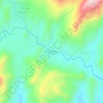
Name: Kalundwa topographic map, elevation, terrain.
Location: Kalundwa, Morogoro, Morogoro Region, Coastal Zone, Tanzania (-6.94615 37.75092 -6.90615 37.79092)
Average elevation: 544 m
Minimum elevation: 366 m
Maximum elevation: 977 m
Thank you for supporting this site ❤️
Make a donation
Make a donation
Gear up for your next adventure:
As an Amazon Associate, this site earns from qualifying purchases at no extra cost to you.