
Make a donation
Gear up for your next adventure:
As an Amazon Associate, this site earns from qualifying purchases at no extra cost to you.
Thaba Nchu topographic map
Click on the map to display elevation.
Make a donation
Gear up for your next adventure:
As an Amazon Associate, this site earns from qualifying purchases at no extra cost to you.
About this map
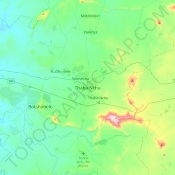
Name: Thaba Nchu topographic map, elevation, terrain.
Average elevation: 1,510 m
Minimum elevation: 1,356 m
Maximum elevation: 2,123 m
Make a donation
Gear up for your next adventure:
As an Amazon Associate, this site earns from qualifying purchases at no extra cost to you.
Other topographic maps
Click on a map to view its topography, its elevation and its terrain.
Mangaung Ward 26
South Africa > Free State > Mangaung Metropolitan Municipality
Average elevation: 1,338 m
Rustfontein Dam
South Africa > Free State > Mangaung Metropolitan Municipality
Average elevation: 1,375 m
Bloemspruit
South Africa > Free State > Mangaung Metropolitan Municipality > Bloemfontein
Average elevation: 1,376 m
Wag-n'-Bietjie Park
South Africa > Free State > Mangaung Metropolitan Municipality > Bloemfontein
Average elevation: 1,411 m
Make a donation
Gear up for your next adventure:
As an Amazon Associate, this site earns from qualifying purchases at no extra cost to you.