
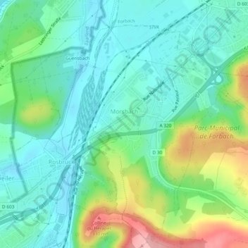
Morsbach topographic map
Interactive map
Click on the map to display elevation.
About this map
Name: Morsbach topographic map, elevation, terrain.
Average elevation: 237 m
Minimum elevation: 194 m
Maximum elevation: 345 m
Other topographic maps
Click on a map to view its topography, its elevation and its terrain.
Schweyen
Frankreich > Grand Est > Mosel
Schweyen, Sarreguemines, Mosel, Grand Est, Metropolitanes Frankreich, 57720, Frankreich
Average elevation: 298 m
Büdingen
Frankreich > Grand Est > Mosel
Büdingen, Diedenhofen, Mosel, Grand Est, Metropolitanes Frankreich, 57920, Frankreich
Average elevation: 220 m
Biningen
Frankreich > Grand Est > Mosel
Biningen, Sarreguemines, Mosel, Grand Est, Metropolitanes Frankreich, 57410, Frankreich
Average elevation: 314 m
Wolsdorf
Frankreich > Grand Est > Mosel
Wolsdorf, Diedenhofen, Mosel, Grand Est, Metropolitanes Frankreich, 57940, Frankreich
Average elevation: 204 m
Sankt Ludwig bei Pfalzburg
Frankreich > Grand Est > Mosel
Sankt Ludwig bei Pfalzburg, Sarrebourg-Château-Salins, Mosel, Grand Est, Metropolitanes Frankreich, 57820, Frankreich
Average elevation: 334 m
Neunkirchen
Frankreich > Grand Est > Mosel
Neunkirchen, Forbach-Bolchen, Mosel, Grand Est, Metropolitanes Frankreich, 57320, Frankreich
Average elevation: 236 m
Metzingen
Frankreich > Grand Est > Mosel
Metzingen, Forbach-Bolchen, Mosel, Grand Est, Metropolitanes Frankreich, 57980, Frankreich
Average elevation: 251 m
Illingen
Frankreich > Grand Est > Mosel
Illingen, Diedenhofen, Mosel, Grand Est, Metropolitanes Frankreich, 57970, Frankreich
Average elevation: 173 m
Bolchen
Frankreich > Grand Est > Mosel
Bolchen, Forbach-Bolchen, Mosel, Grand Est, Metropolitanes Frankreich, 57220, Frankreich
Average elevation: 258 m
Bingen
Frankreich > Grand Est > Mosel
Bingen, Forbach-Bolchen, Mosel, Grand Est, Metropolitanes Frankreich, 57220, Frankreich
Average elevation: 275 m
Forbach
Frankreich > Grand Est > Mosel
Forbach, Forbach-Bolchen, Mosel, Grand Est, Metropolitanes Frankreich, 57600, Frankreich
Average elevation: 253 m
Langenberg
Frankreich > Grand Est > Mosel
Langenberg, Sarrebourg-Château-Salins, Mosel, Grand Est, Metropolitanes Frankreich, 57810, Frankreich
Average elevation: 269 m