
Make a donation
Gear up for your next adventure:
As an Amazon Associate, this site earns from qualifying purchases at no extra cost to you.
Signal Mountain topographic map
Click on the map to display elevation.
Make a donation
Gear up for your next adventure:
As an Amazon Associate, this site earns from qualifying purchases at no extra cost to you.
About this map
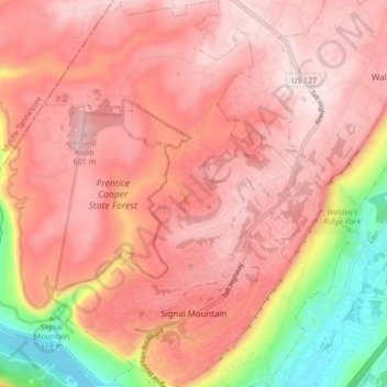
Name: Signal Mountain topographic map, elevation, terrain.
Average elevation: 493 m
Minimum elevation: 191 m
Maximum elevation: 637 m
Make a donation
Gear up for your next adventure:
As an Amazon Associate, this site earns from qualifying purchases at no extra cost to you.
Other topographic maps
Click on a map to view its topography, its elevation and its terrain.
Make a donation
Gear up for your next adventure:
As an Amazon Associate, this site earns from qualifying purchases at no extra cost to you.
Brainerd
United States > Tennessee > Hamilton County > Chattanooga > Ridgeside
Average elevation: 234 m
Shepherd Forest
United States > Tennessee > Hamilton County > Signal Mountain
Average elevation: 459 m
Make a donation
Gear up for your next adventure:
As an Amazon Associate, this site earns from qualifying purchases at no extra cost to you.
North Glen Estates
United States > Tennessee > Hamilton County > Chattanooga > Red Bank
Average elevation: 235 m
Make a donation
Gear up for your next adventure:
As an Amazon Associate, this site earns from qualifying purchases at no extra cost to you.
Mountain Ridge
United States > Tennessee > Hamilton County > Chattanooga > Red Bank
Average elevation: 249 m
Make a donation
Gear up for your next adventure:
As an Amazon Associate, this site earns from qualifying purchases at no extra cost to you.
Make a donation
Gear up for your next adventure:
As an Amazon Associate, this site earns from qualifying purchases at no extra cost to you.
Make a donation
Gear up for your next adventure:
As an Amazon Associate, this site earns from qualifying purchases at no extra cost to you.
Make a donation
Gear up for your next adventure:
As an Amazon Associate, this site earns from qualifying purchases at no extra cost to you.
Regency Place
United States > Tennessee > Hamilton County > Chattanooga > Ridgeside
Average elevation: 234 m
White Oak
United States > Tennessee > Hamilton County > Chattanooga > Red Bank
Average elevation: 242 m
Make a donation
Gear up for your next adventure:
As an Amazon Associate, this site earns from qualifying purchases at no extra cost to you.
Wilder Point
United States > Tennessee > Hamilton County > Signal Mountain > Palisades
Average elevation: 409 m
Make a donation
Gear up for your next adventure:
As an Amazon Associate, this site earns from qualifying purchases at no extra cost to you.
Make a donation
Gear up for your next adventure:
As an Amazon Associate, this site earns from qualifying purchases at no extra cost to you.
Make a donation
Gear up for your next adventure:
As an Amazon Associate, this site earns from qualifying purchases at no extra cost to you.
South Brainerd
United States > Tennessee > Hamilton County > Chattanooga > East Ridge
Average elevation: 223 m
Soddy-Daisy
United States > Tennessee > Hamilton County > Soddy-Daisy > Soddy-Daisy
Average elevation: 307 m
Northshore Estates
United States > Tennessee > Hamilton County > Chattanooga > Northshore Estates
Average elevation: 223 m
Make a donation
Gear up for your next adventure:
As an Amazon Associate, this site earns from qualifying purchases at no extra cost to you.
Brookfield
United States > Tennessee > Hamilton County > East Ridge > Brookfield
Average elevation: 235 m
Make a donation
Gear up for your next adventure:
As an Amazon Associate, this site earns from qualifying purchases at no extra cost to you.