
Bampton topographic map
Click on the map to display elevation.
About this map
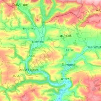
Name: Bampton topographic map, elevation, terrain.
Average elevation: 185 m
Minimum elevation: 82 m
Maximum elevation: 315 m
Devon trails, hiking, mountain biking, running and outdoor activities
Other topographic maps
Click on a map to view its topography, its elevation and its terrain.
Wordland Cross
United Kingdom > England > Devon > Mid Devon > Cheriton Fitzpaine
Average elevation: 120 m
Moor Copse
United Kingdom > England > Devon > Mid Devon > Oakford Bridge > Stoodleigh
Average elevation: 176 m
Brandside Corner
United Kingdom > England > Devon > Mid Devon > Yeoford > Neopardy
Average elevation: 92 m