
Aïn Kercha topographic map
Interactive map
Click on the map to display elevation.
About this map
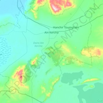
Name: Aïn Kercha topographic map, elevation, terrain.
Location: Aïn Kercha, Aïn Kechra District, Oum El Bouaghi, 04006, Algeria (35.76953 6.60638 35.99411 6.73844)
Average elevation: 875 m
Minimum elevation: 771 m
Maximum elevation: 1,422 m
Other topographic maps
Click on a map to view its topography, its elevation and its terrain.
Hanchir Toumghani
Algeria > Oum El Bouaghi > Aïn Kechra District > Hanchir Toumghani
Hanchir Toumghani, Aïn Kechra District, Oum El Bouaghi, Algeria
Average elevation: 921 m