
Make a donation
Gear up for your next adventure:
As an Amazon Associate, this site earns from qualifying purchases at no extra cost to you.
Timokten topographic map
Click on the map to display elevation.
Make a donation
Gear up for your next adventure:
As an Amazon Associate, this site earns from qualifying purchases at no extra cost to you.
Timokten
The town of Timokten lies at an elevation of 288 metres (945 ft) on the western side of an oasis. Other settlements, such as Zaouiet Moulay Heïba, lie around the northern and eastern sides of this oasis. is a part of the Tidikelt region of the central Sahara that extends from central eastern Adrar Province (where Aoulef is located) to northeast Tamanrasset Province around In Salah. The oases in this region are sparser than in the Tuat and Gourara regions in which most of the population of Adrar Province live, but there are still a number of towns such as Aoulef, Akabli, Tit and In Ghar. The nearby land is mostly flat aside from some small hills to the east; however further north the land rises to the Tademaït plateau.
Make a donation
Gear up for your next adventure:
As an Amazon Associate, this site earns from qualifying purchases at no extra cost to you.
About this map
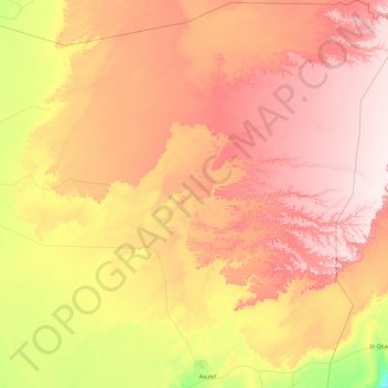
Name: Timokten topographic map, elevation, terrain.
Location: Timokten, Aoulef District, Adrar, 1003, Algeria (26.92294 0.24139 28.57472 2.00131)
Average elevation: 392 m
Minimum elevation: 184 m
Maximum elevation: 621 m
Make a donation
Gear up for your next adventure:
As an Amazon Associate, this site earns from qualifying purchases at no extra cost to you.