
Make a donation
Gear up for your next adventure:
As an Amazon Associate, this site earns from qualifying purchases at no extra cost to you.
Applecross topographic map
Click on the map to display elevation.
Make a donation
Gear up for your next adventure:
As an Amazon Associate, this site earns from qualifying purchases at no extra cost to you.
About this map
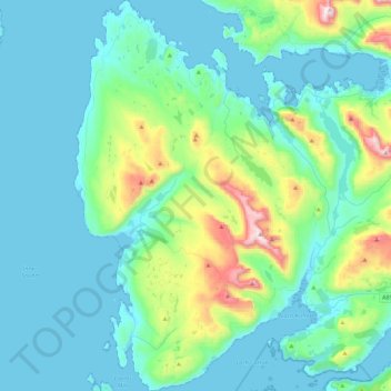
Name: Applecross topographic map, elevation, terrain.
Location: Applecross, Highland, Scotland, United Kingdom (57.34629 -5.87305 57.58604 -5.59579)
Average elevation: 149 m
Minimum elevation: 0 m
Maximum elevation: 904 m
Highland trails, hiking, mountain biking, running and outdoor activities
Make a donation
Gear up for your next adventure:
As an Amazon Associate, this site earns from qualifying purchases at no extra cost to you.
Other topographic maps
Click on a map to view its topography, its elevation and its terrain.
Ben Nevis
United Kingdom > Scotland > Highland
Ben Nevis has a highland (alpine) maritime (oceanic) polar climate (ET climate in the Köppen classification). Ben Nevis's elevation, maritime location and topography frequently lead to cool and cloudy weather conditions, which can pose a danger to ill-equipped walkers. According to the observations carried…
Average elevation: 912 m
Make a donation
Gear up for your next adventure:
As an Amazon Associate, this site earns from qualifying purchases at no extra cost to you.
Scottish Highlands
United Kingdom > Scotland > Highland
The entire region was covered by ice sheets during the Pleistocene ice ages, save perhaps for a few nunataks. The complex geomorphology includes incised valleys and lochs carved by the action of mountain streams and ice, and a topography of irregularly distributed mountains whose summits have similar heights…
Average elevation: 907 m
Make a donation
Gear up for your next adventure:
As an Amazon Associate, this site earns from qualifying purchases at no extra cost to you.
Make a donation
Gear up for your next adventure:
As an Amazon Associate, this site earns from qualifying purchases at no extra cost to you.
Strathpeffer
United Kingdom > Scotland > Highland
It lies in a strath 5 miles (8 km) west of Dingwall, with the elevation ranging from 60 to 120 m (200 to 400 ft) above sea level. Sheltered on the west and north, it has a comparatively dry and warm climate.
Average elevation: 127 m
Make a donation
Gear up for your next adventure:
As an Amazon Associate, this site earns from qualifying purchases at no extra cost to you.
Make a donation
Gear up for your next adventure:
As an Amazon Associate, this site earns from qualifying purchases at no extra cost to you.
Fort William
United Kingdom > Scotland > Highland
Fort William has an oceanic climate (Cfb) with moderate, but generally cool, temperatures and abundant precipitation. In the towns immediate vicinity, there are significant variations in elevation, which leads to some uninhabited areas near the town having a subpolar oceanic climate (Cfc), or, at the absolute…
Average elevation: 122 m
Make a donation
Gear up for your next adventure:
As an Amazon Associate, this site earns from qualifying purchases at no extra cost to you.
Make a donation
Gear up for your next adventure:
As an Amazon Associate, this site earns from qualifying purchases at no extra cost to you.
Make a donation
Gear up for your next adventure:
As an Amazon Associate, this site earns from qualifying purchases at no extra cost to you.
Make a donation
Gear up for your next adventure:
As an Amazon Associate, this site earns from qualifying purchases at no extra cost to you.
Make a donation
Gear up for your next adventure:
As an Amazon Associate, this site earns from qualifying purchases at no extra cost to you.
Make a donation
Gear up for your next adventure:
As an Amazon Associate, this site earns from qualifying purchases at no extra cost to you.
Aonach Beag
United Kingdom > Scotland > Highland
Aonach Beag is linked to its close neighbour to the north, Aonach Mòr, by a high saddle or bealach. The name Aonach Beag (small ridge) might imply that this mountain is smaller than Aonach Mòr (big ridge). However, Aonach Beag is higher; the names refer to the relative bulk of the two mountains rather than…
Average elevation: 873 m
Càrn Eige
United Kingdom > Scotland > Highland
Carn Eighe (Scottish Gaelic: Càrn Èite) is a mountain in the Northwest Highlands of Scotland. Rising to 1,183 metres (3,881 ft) above sea level, it is the highest mountain in Scotland north of the Great Glen, the twelfth-highest in the British Isles, and, in terms of relative height (topographic prominence),…
Average elevation: 867 m
Make a donation
Gear up for your next adventure:
As an Amazon Associate, this site earns from qualifying purchases at no extra cost to you.
Ben Klibreck
United Kingdom > Scotland > Highland
Ben Klibreck (Scottish Gaelic: Beinn Chlìbric) is a Scottish mountain located in central Sutherland. It is an isolated mountain, rising above a large area of moorland. The highest point, Meall nan Con (the mound of the dogs), rises to 962 metres (3,156 ft) elevation and is therefore the second most northerly…
Average elevation: 551 m
Canisp
United Kingdom > Scotland > Highland
Canisp is an isolated mountain that stands in the Glencanisp Forest, a large rock and water wilderness. It has a topographic prominence of 691 metres (2,267 ft). Canisp has little vegetation, even on its lower slopes large areas of Gneiss (one of the oldest rocks in the world) are visible on the surface.
Average elevation: 467 m
Make a donation
Gear up for your next adventure:
As an Amazon Associate, this site earns from qualifying purchases at no extra cost to you.
Make a donation
Gear up for your next adventure:
As an Amazon Associate, this site earns from qualifying purchases at no extra cost to you.
Sgùrr Fhuaran
United Kingdom > Scotland > Highland
The mountain reaches a height of 1,067 metres (3,501 ft) and qualifies as a Munro and a Marilyn; it is the highest point for a significant distance, having a sizeable topographic prominence of 663 metres (2,175 ft) and giving extensive views from its summit.
Average elevation: 604 m
Sgùrr na Càrnach
United Kingdom > Scotland > Highland
From 1891 to 1997 Sgùrr na Càrnach was ranked as just a "Top" of the nearby Munro of Sgùrr Fhuraran and was not given separate Munro status, however in the 1997 revision of the tables by the Scottish Mountaineering Club, the mountain was elevated to the Munro category as it was decided that with 134 metres…
Average elevation: 589 m
Make a donation
Gear up for your next adventure:
As an Amazon Associate, this site earns from qualifying purchases at no extra cost to you.
Make a donation
Gear up for your next adventure:
As an Amazon Associate, this site earns from qualifying purchases at no extra cost to you.
Sgúrr nan Eugallt
United Kingdom > Scotland > Highland
An old stalkers' path from the ruined cottage should guide the climber to a point just below a ridge at about 650 metres. The path was well built in its time but some sections have become wet and slippery. On gaining the ridge, turn left and follow the ridge to the 894 m triangulation point. The ridge becomes…
Average elevation: 539 m
Make a donation
Gear up for your next adventure:
As an Amazon Associate, this site earns from qualifying purchases at no extra cost to you.
Make a donation
Gear up for your next adventure:
As an Amazon Associate, this site earns from qualifying purchases at no extra cost to you.
Make a donation
Gear up for your next adventure:
As an Amazon Associate, this site earns from qualifying purchases at no extra cost to you.
Make a donation
Gear up for your next adventure:
As an Amazon Associate, this site earns from qualifying purchases at no extra cost to you.
Make a donation
Gear up for your next adventure:
As an Amazon Associate, this site earns from qualifying purchases at no extra cost to you.
Make a donation
Gear up for your next adventure:
As an Amazon Associate, this site earns from qualifying purchases at no extra cost to you.
Make a donation
Gear up for your next adventure:
As an Amazon Associate, this site earns from qualifying purchases at no extra cost to you.
Make a donation
Gear up for your next adventure:
As an Amazon Associate, this site earns from qualifying purchases at no extra cost to you.
Newtonmore
United Kingdom > Scotland > Highland
Newtonmore is located within the Cairngorms National Park, approximately 3 miles (5 km) southwest of Kingussie and 15 miles (24 km) southwest of Aviemore. It is on the northeastern bank of the River Spey, between the River Calder and the Allt Lairaidh, at an altitude of approximately 250 metres (820 ft).
Average elevation: 283 m
Make a donation
Gear up for your next adventure:
As an Amazon Associate, this site earns from qualifying purchases at no extra cost to you.