
龙州县 topographic map
Interactive map
Click on the map to display elevation.
About this map
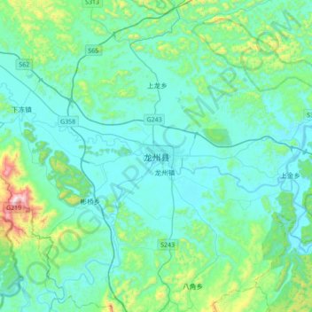
Name: 龙州县 topographic map, elevation, terrain.
Location: 龙州县, 崇左市, 广西壮族自治区, 中国 (22.18633 106.69074 22.50633 107.01074)
Average elevation: 240 m
Minimum elevation: 107 m
Maximum elevation: 1,010 m
西北高,中南低。以喀斯特地形石山为主,很多独立的小山峰陡而散碎,连绵的有下冻和彬桥之间的“大青山”,主峰海拔1045米,尽管在地形图上看大体是统一的绿色,但实际上还是以山地为主。地下多暗河,发源于越南的水口河、平而河、明江于境内汇合成为左江(珠江水系),但左江龙州段本地一般称为“丽江”。丽江两岸风景类似桂林,但山体更大,多崖壁。
Other topographic maps
Click on a map to view its topography, its elevation and its terrain.