Geolocate

Basel topographic map

Click on the map to display elevation.

About this map

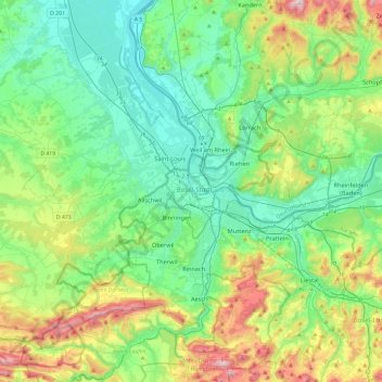
Name: Basel topographic map, elevation, terrain.

Location: Basel, Basel-City, 4001, Switzerland (47.39811 7.42783 47.71811 7.74783)

Average elevation: 404 m

Minimum elevation: 216 m

Maximum elevation: 931 m

Other topographic maps

Click on a map to view its topography, its elevation and its terrain.

Grossbasel

Switzerland > Basel-City > Basel

Average elevation: 288 m

Claramatte

Switzerland > Basel-City > Basel

Average elevation: 264 m

Grossbasel

Switzerland > Basel-City > Basel

Average elevation: 288 m

Gear up for your next adventure:

🛰️Outdoor GPS Navigation - Navigation devices for remote and off-grid areas
🔦Outdoor Torches - Reliable torches for night navigation
🧣Fleece Neck Warmers - Extra insulation for winter topographic surveys
🧗Locking Carabiners - Secure gear to your pack or for light technical use
GPS Outdoor Watches - Watches with GPS tracking for hiking and exploration

As an Amazon Associate, this site earns from qualifying purchases at no extra cost to you.