Geolocate

Lumding topographic map

Click on the map to display elevation.

About this map

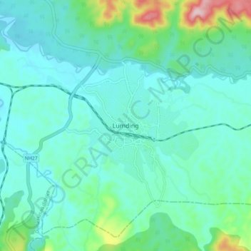
Name: Lumding topographic map, elevation, terrain.

Location: Lumding, Lanka, Hojai, Assam, 782447, India (25.71354 93.13317 25.79354 93.21317)

Average elevation: 159 m

Minimum elevation: 109 m

Maximum elevation: 388 m

Gear up for your next adventure:

🧤Thermal Touchscreen Gloves - Stay warm while operating your GPS or smartphone camera
🔭Compact Hiking Binoculars - Lightweight optics for scouting terrain and spotting wildlife
🧣Neck Gaiters - Versatile protection against wind and cold
🧤Waterproof Overmitts - Extreme weather protection for hikers and mountaineers
🪓Outdoor Multitools - Versatile tools for hiking and camping

As an Amazon Associate, this site earns from qualifying purchases at no extra cost to you.