
Make a donation
Gear up for your next adventure:
As an Amazon Associate, this site earns from qualifying purchases at no extra cost to you.
Volcán Socompa topographic map
Click on the map to display elevation.
Make a donation
Gear up for your next adventure:
As an Amazon Associate, this site earns from qualifying purchases at no extra cost to you.
Volcán Socompa
El volcán Socompa es un estratovolcán de Suramérica ubicado entre el límite de la Región de Antofagasta, Chile y la Provincia de Salta, Argentina. Este estratovolcán tiene una altitud de 6031 m y es una de las cumbres salteñas más altas.
Make a donation
Gear up for your next adventure:
As an Amazon Associate, this site earns from qualifying purchases at no extra cost to you.
About this map
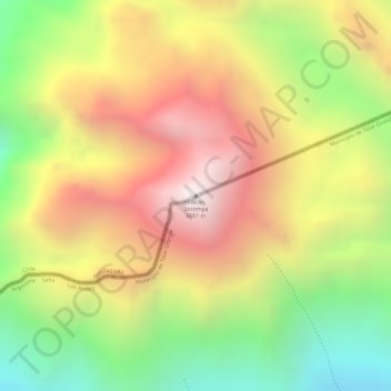
Name: Volcán Socompa topographic map, elevation, terrain.
Average elevation: 5,508 m
Minimum elevation: 4,908 m
Maximum elevation: 6,034 m
Make a donation
Gear up for your next adventure:
As an Amazon Associate, this site earns from qualifying purchases at no extra cost to you.
Other topographic maps
Click on a map to view its topography, its elevation and its terrain.
Reserva Nacional La Chimba
Chile > Región de Antofagasta > Provincia de Antofagasta > Antofagasta
Average elevation: 750 m