
Le Grand Morétan topographic map
Interactive map
Click on the map to display elevation.
About this map
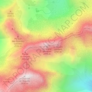
Name: Le Grand Morétan topographic map, elevation, terrain.
Average elevation: 2,307 m
Minimum elevation: 1,701 m
Maximum elevation: 2,803 m
Other topographic maps
Click on a map to view its topography, its elevation and its terrain.
Puy Gris
France > Auvergne-Rhône-Alpes > Savoy > Saint-Colomban-des-Villards
Puy Gris, Saint-Colomban-des-Villards, Saint-Jean-de-Maurienne, Savoy, Auvergne-Rhône-Alpes, Metropolitan France, 73130, France
Average elevation: 2,469 m