
Toolik Field Station topographic map
Interactive map
Click on the map to display elevation.
About this map
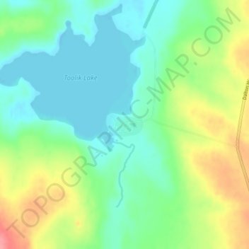
Name: Toolik Field Station topographic map, elevation, terrain.
Location: Toolik Field Station, North Slope, Alaska, United States (68.62632 -149.59989 68.62884 -149.58870)
Average elevation: 740 m
Minimum elevation: 714 m
Maximum elevation: 795 m
Other topographic maps
Click on a map to view its topography, its elevation and its terrain.
Prudhoe Bay
United States > Alaska > North Slope
Prudhoe Bay, North Slope, Alaska, 99734, United States
Average elevation: 10 m
Chandalar Shelf
United States > Alaska > North Slope
Chandalar Shelf, North Slope, Alaska, United States
Average elevation: 974 m
Toolik River
United States > Alaska > North Slope
Toolik River, North Slope, Alaska, United States
Average elevation: 126 m
Kaktovik
United States > Alaska > North Slope > Kaktovik
Kaktovik, North Slope, Alaska, 99747, United States
Average elevation: 5 m
Point Barrow
United States > Alaska > North Slope
Point Barrow, North Slope, Alaska, United States
Average elevation: 0 m
Deadhorse
United States > Alaska > North Slope
Deadhorse, North Slope, Alaska, 99734, United States
Average elevation: 14 m
Utqiaġvik
United States > Alaska > North Slope
Utqiaġvik, North Slope, Alaska, 99273, United States
Average elevation: 4 m