
Nedumkandom topographic map
Interactive map
Click on the map to display elevation.
About this map
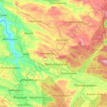
Name: Nedumkandom topographic map, elevation, terrain.
Location: Nedumkandom, Nedumkandam, Idukki, Kerala, 685553, India (9.81111 77.09624 9.90119 77.24387)
Average elevation: 938 m
Minimum elevation: 550 m
Maximum elevation: 1,390 m
Other topographic maps
Click on a map to view its topography, its elevation and its terrain.
Nedumkandam
India > Kerala > Nedumkandam > Idukki
Nedumkandam, Udumbanchola, Idukki, Kerala, India
Average elevation: 952 m