
Make a donation
Gear up for your next adventure:
As an Amazon Associate, this site earns from qualifying purchases at no extra cost to you.
Purani topographic map
Click on the map to display elevation.
Make a donation
Gear up for your next adventure:
As an Amazon Associate, this site earns from qualifying purchases at no extra cost to you.
About this map
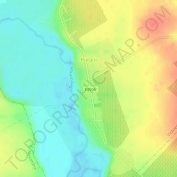
Name: Purani topographic map, elevation, terrain.
Location: Purani, Vitănești, Teleorman, 147441, Romania (43.97089 25.42365 43.99790 25.44459)
Average elevation: 62 m
Minimum elevation: 40 m
Maximum elevation: 89 m
Make a donation
Gear up for your next adventure:
As an Amazon Associate, this site earns from qualifying purchases at no extra cost to you.
Other topographic maps
Click on a map to view its topography, its elevation and its terrain.
Make a donation
Gear up for your next adventure:
As an Amazon Associate, this site earns from qualifying purchases at no extra cost to you.
Turnu Măgurele
A ferry plies across the Danube to the Bulgarian city of Nikopol. There are some vestiges of a Roman bridge across the Danube, built in 330 by Constantine the Great. It is built in the Danube plain in a fertile land called Burnas plain. At 4 km (2.5 mi) south-west from it the river Olt joins the Danube. Its…
Average elevation: 59 m
Make a donation
Gear up for your next adventure:
As an Amazon Associate, this site earns from qualifying purchases at no extra cost to you.
Make a donation
Gear up for your next adventure:
As an Amazon Associate, this site earns from qualifying purchases at no extra cost to you.