
Näfels topographic map
Interactive map
Click on the map to display elevation.
About this map
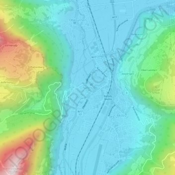
Name: Näfels topographic map, elevation, terrain.
Location: Näfels, Glarus Nord, Glarus, 8752, Schweiz (47.07978 9.04301 47.11978 9.08301)
Average elevation: 687 m
Minimum elevation: 424 m
Maximum elevation: 1,606 m
Other topographic maps
Click on a map to view its topography, its elevation and its terrain.
Judenweg
Schweiz > Glarus > Glarus Nord
Judenweg, Glarus Nord, Glarus, 8874, Schweiz
Average elevation: 1,736 m
Obstalden
Schweiz > Glarus > Glarus Nord
Obstalden, Glarus Nord, Glarus, 8758, Schweiz
Average elevation: 732 m
Mollis
Schweiz > Glarus > Glarus Nord
Mollis, Glarus Nord, Glarus, 8753, Schweiz
Average elevation: 726 m