
Banner Creek Lake topographic map
Interactive map
Click on the map to display elevation.
About this map
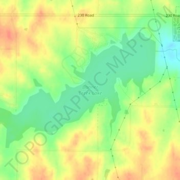
Name: Banner Creek Lake topographic map, elevation, terrain.
Location: Banner Creek Lake, Jackson County, Kansas, United States (39.44195 -95.80115 39.46050 -95.76377)
Average elevation: 340 m
Minimum elevation: 316 m
Maximum elevation: 361 m
Other topographic maps
Click on a map to view its topography, its elevation and its terrain.
Delia
United States > Kansas > Jackson County
Delia, Jackson County, Kansas, United States
Average elevation: 302 m