
Arusha topographic map
Click on the map to display elevation.
Arusha
Despite its proximity to the equator, Arusha's elevation of 1,400 metres (4,600 ft) on the southern slopes of Mount Meru keeps temperatures relatively low and alleviates humidity. Cool dry air is prevalent for much of the year. The temperature typically ranges between 10 and 30 °C (50 and 86 °F) with an average annual high temperature around 25 °C or 77 °F. It has distinct wet and dry seasons, and experiences an eastern prevailing wind from the Indian Ocean, a few hundred kilometres east. Under the Köppen climate classification system, it has a subtropical highland climate (Cwb). Areas away from Arusha to the south and west are classified as tropical savanna climate (Aw).
About this map
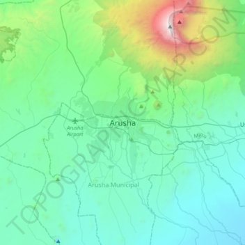
Name: Arusha topographic map, elevation, terrain.
Average elevation: 1,572 m
Minimum elevation: 966 m
Maximum elevation: 4,530 m
Other topographic maps
Click on a map to view its topography, its elevation and its terrain.
Monduli
A number of isolated mountains (Monduli, Lepurko, Loosimingori, and Lengai) and broad rolling plains characterize the land landscape. The heights range from 600m in the low elevations to 2900m in the high elevations. The District's vegetation includes a combination of forest, bushland, woodland grassland, and…
Average elevation: 1,369 m
Karatu
Karatu District (Wilaya ya Karatu, in Swahili) is one of seven districts of the Arusha Region of Tanzania. The district is bordered to the north by the Ngorongoro District and to the west by the Meatu District in the Simiyu Region. The district is bordered to the east by the Monduli District, and to the south…
Average elevation: 1,468 m
Ngorongoro Conservation Area
The southern and eastern boundaries of the Serengeti ecosystem are approximately defined by the rim of the East African Rift wall, which also prevents animal migration in these directions. In the topographical map, Lake Nyanza is the same as Lake Victoria in the Serengeti Ecosystem map.
Average elevation: 1,604 m
Monduli
A number of isolated mountains (Monduli, Lepurko, Loosimingori, and Lengai) and broad rolling plains characterize the land landscape. The heights range from 600m in the low elevations to 2900m in the high elevations. The District's vegetation includes a combination of forest, bushland, woodland grassland, and…
Average elevation: 1,369 m