
Kings Canyon National Park topographic map
Interactive map
Click on the map to display elevation.
Kings Canyon National Park
Kings Canyon is characterized by some of the steepest vertical relief in North America, with numerous peaks over 14,000 feet (4,300 m) on the Sierra Crest along the park's eastern border, falling to 4,500 feet (1,400 m) in the valley floor of Cedar Grove just ten miles (16 km) to the west. The Sierran crest forms the eastern boundary of the park, from Mount Goethe in the north, down to Junction Peak, at the boundary with Sequoia National Park. Several passes cross the crest into the park, including Bishop Pass, Taboose Pass, Sawmill Pass, and Kearsarge Pass. All of these passes are above 11,000 feet (3,400 m) in elevation.
About this map
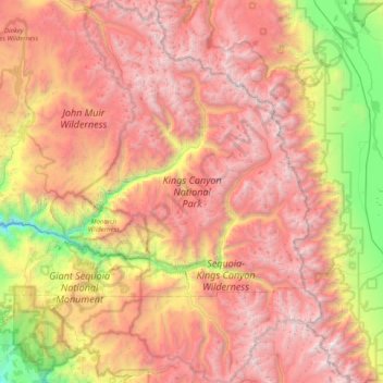
Name: Kings Canyon National Park topographic map, elevation, terrain.
Average elevation: 2,591 m
Minimum elevation: 630 m
Maximum elevation: 4,372 m
Other topographic maps
Click on a map to view its topography, its elevation and its terrain.
Friant
United States > California > Fresno County > Friant
Friant (formerly, Converse Ferry, Jones Ferry, Hamptonville, and Pollasky) is a census-designated place (CDP) in Fresno County, California, United States. The population was 549 at the 2010 census, down from 778 at the 2000 census. Friant is located 11.5 miles (19 km) north of Clovis, at an elevation of 344…
Average elevation: 135 m
Shaver Lake
United States > California > Fresno County > Shaver Lake
Shaver Lake (formerly, Musick Creek and Musick Creek Heights) is a census-designated place (CDP) in Fresno County, California, United States. The population was 634 at the 2010 census, down from 705 at the 2000 census. Shaver Lake is on the southwest end of the lake of the same name, 10 miles (16 km) east of…
Average elevation: 1,437 m
Reedley
United States > California > Fresno County
Reedley is a city in Fresno County, California, United States. It is located in the San Joaquin Valley, 22 miles (35 km) east-southeast of Fresno, at an elevation of 348 feet (106 m). The population at the 2010 census was 24,194. Its chief economic source is agriculture, particularly fruit and vegetable…
Average elevation: 106 m
Yokuts Valley
United States > California > Fresno County
As of the 2010 census, the CDP had a total population of 3,162, up from 2,691 at the 2000 census. For statistical purposes, the United States Census Bureau defined Squaw Valley as a census-designated place (CDP). Yokuts Valley is located 9 miles (14 km) north-northeast of Orange Cove and 30 miles (48 km) east…
Average elevation: 550 m