
North Dumdum topographic map
Interactive map
Click on the map to display elevation.
About this map
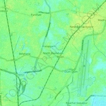
Name: North Dumdum topographic map, elevation, terrain.
Average elevation: 6 m
Minimum elevation: -3 m
Maximum elevation: 23 m
Other topographic maps
Click on a map to view its topography, its elevation and its terrain.
Kamarhati
India > West Bengal > Barrackpur - II > Kamarhati
Kamarhati, Barrackpur - II, North 24 Parganas, West Bengal, 700058, India
Average elevation: 6 m
Kamarhati Municipality children's park
India > West Bengal > Barrackpur - II > Kolkata
Kamarhati Municipality children's park, Kolkata, Barrackpur - II, North 24 Parganas, West Bengal, 700058, India
Average elevation: 5 m
Panihati
India > West Bengal > Barrackpur - II > Panihati
Panihati, Barrackpur - II, North 24 Parganas, West Bengal, 700111, India
Average elevation: 6 m