Geolocate

La Neuveville topographic map

Interactive map

Click on the map to display elevation.

About this map

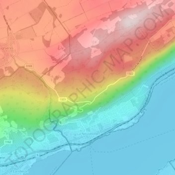
Name: La Neuveville topographic map, elevation, terrain.

Location: La Neuveville, Bernese Jura administrative district, Bernese Jura administrative region, Bern, 2520, Switzerland (47.05973 7.07700 47.08831 7.13410)

Average elevation: 642 m

Minimum elevation: 425 m

Maximum elevation: 928 m

Other topographic maps

Click on a map to view its topography, its elevation and its terrain.

Chaindon

Switzerland > Bern > Bernese Jura administrative district > Reconvilier

Chaindon, Reconvilier, Bernese Jura administrative district, Bernese Jura administrative region, Bern, 2732, Switzerland

Average elevation: 845 m

Renan (BE)

Switzerland > Bern > Bernese Jura administrative district > Renan (BE)

Renan (BE), Bernese Jura administrative district, Bernese Jura administrative region, Bern, 2616, Switzerland

Average elevation: 1,073 m

Courtelary

Switzerland > Bern > Bernese Jura administrative district

Courtelary, Bernese Jura administrative district, Bernese Jura administrative region, Bern, 2608, Switzerland

Average elevation: 1,059 m