
Make a donation
Gear up for your next adventure:
As an Amazon Associate, this site earns from qualifying purchases at no extra cost to you.
Canida Peak topographic map
Click on the map to display elevation.
Make a donation
Gear up for your next adventure:
As an Amazon Associate, this site earns from qualifying purchases at no extra cost to you.
About this map
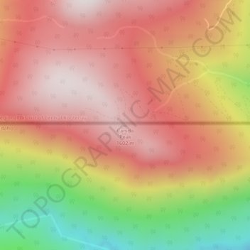
Name: Canida Peak topographic map, elevation, terrain.
Location: Canida Peak, Boundary County, Idaho, United States (48.99962 -116.65027 48.99972 -116.65017)
Average elevation: 1,345 m
Minimum elevation: 814 m
Maximum elevation: 1,676 m
Make a donation
Gear up for your next adventure:
As an Amazon Associate, this site earns from qualifying purchases at no extra cost to you.
Other topographic maps
Click on a map to view its topography, its elevation and its terrain.
Bonners Ferry
United States > Idaho > Boundary County
Bonners Ferry is located 27 miles (43.5 km) south of the Canada-United States border at 48°41′32″N 116°19′3″W / 48.69222°N 116.31750°W / 48.69222; -116.31750 (48.692110, −116.317626), at an altitude of 1,896 feet (578 m). According to the United States Census Bureau, the city has a total…
Average elevation: 584 m
Make a donation
Gear up for your next adventure:
As an Amazon Associate, this site earns from qualifying purchases at no extra cost to you.