
Thank you for supporting this site ❤️
Make a donation
Make a donation
Gear up for your next adventure:
As an Amazon Associate, this site earns from qualifying purchases at no extra cost to you.
Haverfordwest topographic map
Click on the map to display elevation.
Thank you for supporting this site ❤️
Make a donation
Make a donation
Gear up for your next adventure:
As an Amazon Associate, this site earns from qualifying purchases at no extra cost to you.
About this map
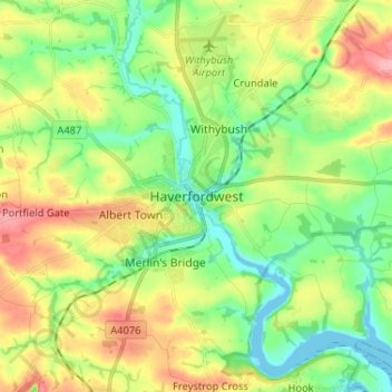
Name: Haverfordwest topographic map, elevation, terrain.
Location: Haverfordwest, Pembrokeshire, Wales, SA61 2NL, United Kingdom (51.76233 -5.00511 51.84233 -4.92511)
Average elevation: 41 m
Minimum elevation: 0 m
Maximum elevation: 104 m
Wales trails, hiking, mountain biking, running and outdoor activities
Thank you for supporting this site ❤️
Make a donation
Make a donation
Gear up for your next adventure:
As an Amazon Associate, this site earns from qualifying purchases at no extra cost to you.