
Mechelen topographic map
Interactive map
Click on the map to display elevation.
About this map
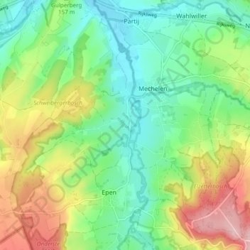
Name: Mechelen topographic map, elevation, terrain.
Location: Mechelen, Gulpen-Wittem, Limbourg, Pays-Bas (50.77136 5.88254 50.80735 5.95771)
Average elevation: 157 m
Minimum elevation: 94 m
Maximum elevation: 269 m
Other topographic maps
Click on a map to view its topography, its elevation and its terrain.
Gulpen-Wittem
Pays-Bas > Limbourg > Gulpen-Wittem
Gulpen-Wittem, Limbourg, Pays-Bas
Average elevation: 164 m